This guide is written in two parts. English first, Korean below. 이 글은 두 파트로 되어 있습니다. 영문이 먼저, 한국어가 아래에 있습니다.
PART 1 — ENGLISH
Two things you have probably heard about Google Maps in Korea, and both are misleading.
The first: “Google Maps doesn’t work in Korea.” It does — just not for the thing you need most.
The second: “They fixed it in February 2026.” The government did grant permission. The feature still is not live.
Here is the accurate picture as of August 2026, and what to actually put on your phone before you land.
1. What works and what doesn’t
Google Maps is not blank in Korea. Most of it behaves normally:
| Works | Doesn’t work |
|---|---|
| Viewing the map | Walking directions (turn-by-turn) |
| Searching for places | Driving navigation |
| Reviews, photos, opening hours | Cycling directions |
| Subway and bus routes | Step-by-step guidance inside transit walking segments |
The surprise for most visitors is that public transit directions do work. Seoul Metro publishes open transit data, so Google’s subway routing is reasonably accurate. If you want to know which line to take from Hongdae to Gangnam, Google Maps will tell you.
What it will not do is walk you there — and the way it fails is worth seeing, because it is not subtle.
Ask for directions between two points in Seoul and look at the row of travel modes across the top. Transit shows a time. Driving, walking and cycling show a dash. Those three are simply not calculated. You do not get a bad route; you get no route.
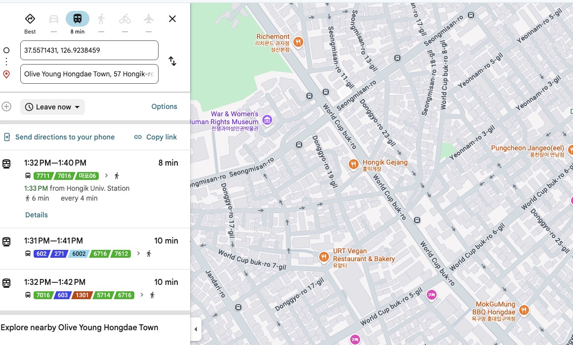
The give-away is what Google offers instead. Put in a destination a few hundred metres away and every suggestion that comes back is a bus — and most of the quoted journey time is spent walking to the stop and away from it again, for a distance you could have covered on foot without stopping. Not one of the alternatives says “walk.” Google is not being obtuse. Transit is the only mode it is allowed to compute, so transit is the only answer it has.
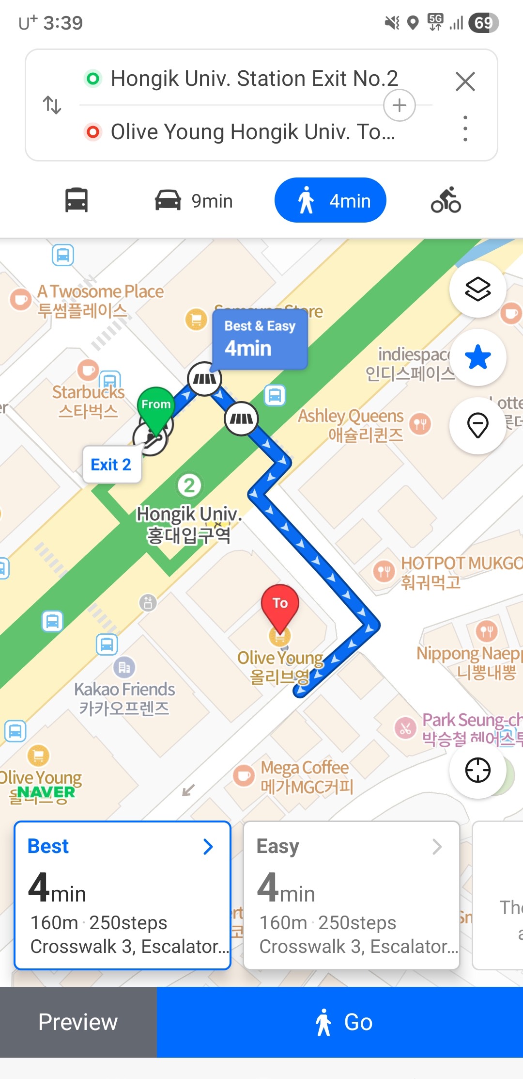
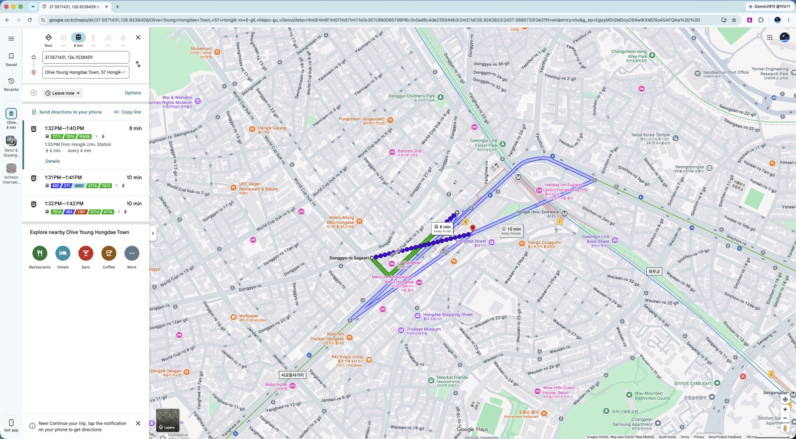
Inside a transit route the same gap appears. The walking legs — station exit to your destination — come with no step-by-step guidance.
That last part matters more than it sounds. Korean subway stations often have a dozen or more exits spread across several blocks. Coming out of the wrong one can mean a fifteen-minute correction.

One more thing the apps will not warn you about: on buses you have to tap your card again when getting off. Skip it and you lose the transfer discount — see the tap-out rule.
2. Why it doesn’t work
Korean law restricts exporting high-precision map data to servers outside the country. Google has served Korean maps from domestic servers since 2008, but the features that need Google’s own processing — walking directions, turn-by-turn navigation — were never possible under that arrangement.
Google’s position is that routing requires “the enormous computing power of data centers distributed around the world,” which is why exporting the data is necessary rather than optional (Google Korea Q&A, August 2025).
Worth noting: the data Google asked for is the 1:5000 national base map — already cleared through security review and already used by Naver and Kakao. The dispute was never about whether the data is secret.
3. What changed in February 2026 — and what didn’t
On February 27, 2026, an inter-agency committee under the National Geographic Information Institute approved conditional export of the 1:5000 high-precision map, closing an argument that had run for 18 years (ZDNet Korea).
The committee included the Ministry of Land, the Ministry of National Defense, the National Intelligence Service, the Ministry of Foreign Affairs, and several others. Approval came with security conditions: imagery processing, restrictions on coordinate display, and continued use of domestic servers. The permission is limited to navigation and routing (Byline Network).
Headlines at the time read like the problem was solved. It is not, yet.
As of August 2026 — roughly six months after approval — walking and driving navigation still are not available in Google Maps in Korea, and no launch date has been announced.
So if you read in February that Google Maps now works in Korea, that was permission being granted, not a feature shipping. Plan your trip on the assumption that it still does not work. If it launches while you are here, that is a bonus.
4. Naver Map — install this one
If you install one app, make it Naver Map. It has the strongest English support of the Korean options, accurate walking directions, and the most complete business listings — hours, photos, reviews, and which exit to use.
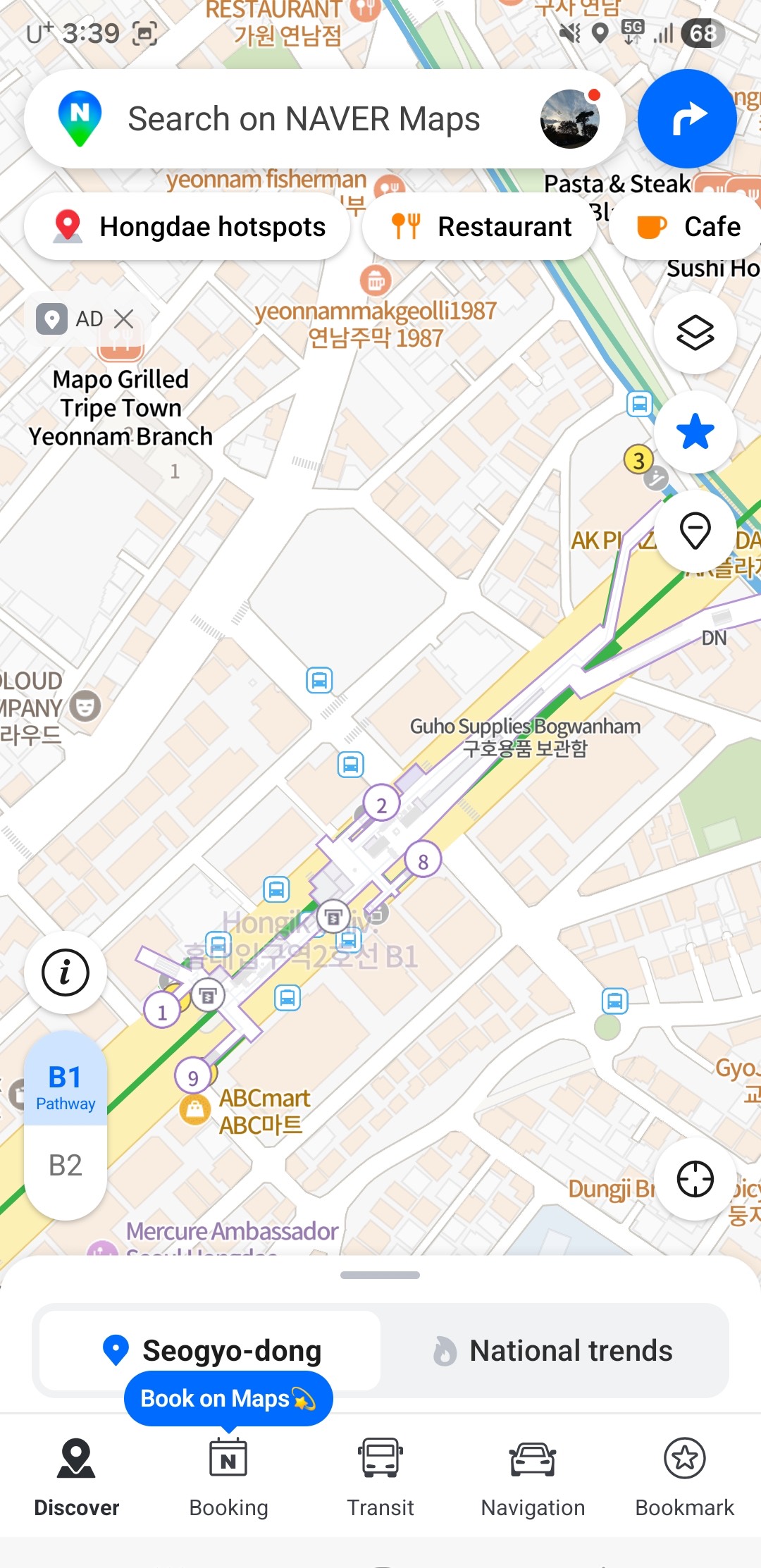
It is probably already in English. Naver Map follows your phone’s language setting, so if your device is in English the app opens that way — no setup needed. Open it and check before hunting through menus.
If it opened in Korean, switch it:
- Tap the menu icon (☰) in the top-left
- Tap the gear icon (⚙️) to open settings
- Find 언어 (Language) and choose English
- The app restarts in English — buttons, directions, and station names
On desktop, go to map.naver.com, click the profile icon, and choose English in settings.
(App layouts change with updates. If the icons have moved, look for the gear first, then the language entry.)
Two things worth knowing:
- You do not need an account. When a login screen appears, tap Skip or use Guest Mode. All core navigation works without a Korean phone number.
- Place names often show in both Korean and English. This is deliberate and useful — you can show the Korean name to a taxi driver or shop staff.
The limits: some reviews and smaller place names stay in Korean, and offline use is limited. Real-time navigation and transit need a connection.
5. Kakao Map — the backup
KakaoMap covers driving, walking, cycling, and public transit, and locals use it heavily. Its transit routing is as good as Naver’s.
Its English support is weaker than Naver’s, so as a visitor it is harder to lean on as your only app.
Where it earns its place on your phone: as a second opinion. Map apps disagree — about which exit is closest, whether a small shop is still open, how a complicated transfer actually works. When Naver gives you something that looks wrong, checking Kakao takes ten seconds.
If you are only installing one app, install Naver. If you have room for two, this is the second.
6. Before you arrive
- Install Naver Map before you fly — download over your home wifi, not airport data
- Switch it to English: ☰ → ⚙️ → 설정 → 언어 → English
- Skip the login. No Korean phone number needed
- Consider KakaoMap as a backup for cross-checking
- Google Maps is still fine for subway routes — keep it, just do not rely on it to walk you anywhere
- Do not assume the February 2026 approval means navigation works. Check on arrival; as of August 2026 it does not
PART 2 — 한국어
한국의 구글 지도에 대해 흔히 듣는 말이 두 가지 있고, 둘 다 정확하지 않습니다.
첫째, “한국에서는 구글 지도가 안 된다.” 됩니다. 다만 가장 필요한 기능이 안 될 뿐입니다.
둘째, “2026년 2월에 해결됐다.” 정부가 허가한 것은 맞습니다. 서비스는 아직 시작되지 않았습니다.
2026년 8월 기준으로 정확한 상황과, 입국 전에 무엇을 준비해야 하는지 정리합니다.
1. 되는 것과 안 되는 것
한국에서 구글 지도가 백지로 나오지는 않습니다. 대부분은 정상적으로 작동합니다.
| 됨 | 안 됨 |
|---|---|
| 지도 보기 | 도보 길찾기 (단계별 안내) |
| 장소 검색 | 자동차 내비게이션 |
| 리뷰·사진·영업시간 | 자전거 길찾기 |
| 지하철·버스 경로 | 대중교통 경로 안의 도보 구간 안내 |
대부분의 방문자가 의외로 여기는 지점은 대중교통 길찾기가 된다는 것입니다. 서울교통공사가 공개 교통 데이터를 제공하기 때문에 지하철 경로는 상당히 정확합니다. 홍대에서 강남까지 어느 노선을 타야 하는지는 구글 지도가 알려줍니다.
하지만 걸어서 데려다주지는 않습니다. 그리고 실패하는 방식이 꽤 노골적입니다.
서울 안에서 두 지점을 놓고 길찾기를 하면 화면 위쪽 이동수단 줄을 보세요. 대중교통에만 시간이 나오고 자동차·도보·자전거는 대시(—)입니다. 계산 자체를 하지 않습니다. 부정확한 경로가 나오는 게 아니라 아예 경로가 없습니다.
결정적인 건 대신 내놓는 답입니다. 몇백 미터 거리를 넣으면 돌아오는 안내가 전부 버스이고, 그 소요시간의 상당 부분이 정류장까지 걸어가고 내려서 다시 걸어가는 시간입니다. 그냥 쉬지 않고 걸으면 되는 거리인데도요. 대안 중 어느 것도 “걸으세요”라고 하지 않습니다. 구글이 어리석은 게 아니라, 계산할 수 있는 유일한 수단이 대중교통이라 그 답밖에 못 내놓는 것입니다.
대중교통 경로 안에서도 같은 구멍이 생깁니다. 지하철 출구에서 목적지까지의 도보 구간에는 단계별 안내가 없습니다.
이 마지막 부분이 생각보다 중요합니다. 한국 지하철역은 출구가 열 개를 넘고 여러 블록에 흩어져 있는 경우가 많습니다. 잘못된 출구로 나오면 15분을 되돌아가야 할 수도 있습니다.
지도 앱이 알려주지 않는 것이 하나 더 있습니다. 버스는 내릴 때도 카드를 대야 합니다. 놓치면 환승 할인을 잃습니다 — 하차 태그 규칙에 정리했습니다.
2. 왜 안 되나
한국 법은 정밀 지도 데이터를 국외 서버로 반출하는 것을 제한합니다. 구글은 2008년부터 국내 서버를 통해 한국 지도를 서비스해 왔지만, 구글 자체 연산이 필요한 기능 — 도보 길찾기, 턴바이턴 내비게이션 — 은 그 구조에서 제공할 수 없었습니다.
구글의 설명은 길찾기가 “전 세계에 분산된 데이터센터의 막대한 컴퓨팅 파워”를 필요로 하기 때문에 반출이 선택이 아니라 필수라는 것입니다(구글코리아 Q&A, 2025년 8월).
짚어둘 점은, 구글이 요청한 데이터가 1:5000 국가기본도라는 사실입니다. 이미 보안심사를 통과한 공개 데이터이고 네이버와 카카오도 쓰고 있습니다. 이 논쟁은 데이터가 비밀이냐 아니냐의 문제가 아니었습니다.
3. 2026년 2월에 바뀐 것, 그리고 아직 안 바뀐 것
2026년 2월 27일, 국토지리정보원 산하 협의체가 1:5000 고정밀 지도의 조건부 국외반출을 허가하면서 18년간 이어진 논쟁이 마무리됐습니다(ZDNet Korea).
협의체에는 국토교통부, 국방부, 국가정보원, 외교부 등 관계 부처가 참여했습니다. 허가에는 영상 보안처리, 좌표 표시 제한, 국내 서버 활용이라는 조건이 붙었고, 범위는 내비게이션·길찾기로 한정됐습니다(바이라인네트워크).
당시 기사 제목만 보면 문제가 해결된 것처럼 읽힙니다. 아직 아닙니다.
2026년 8월 현재, 허가로부터 약 6개월이 지났지만 구글 지도의 도보·자동차 길찾기는 여전히 제공되지 않으며 서비스 개시 일정도 발표되지 않았습니다.
2월에 “이제 한국에서 구글 지도가 된다”는 기사를 봤다면, 그건 허가가 났다는 뜻이지 기능이 나왔다는 뜻이 아닙니다. 아직 안 된다는 전제로 여행을 계획하세요. 머무는 동안 시작되면 그건 덤입니다.
4. 네이버지도 — 이건 꼭 까세요
하나만 설치한다면 네이버지도입니다. 한국 앱 중 영어 지원이 가장 낫고, 도보 안내가 정확하며, 업체 정보(영업시간·사진·리뷰·출입구)가 가장 충실합니다.
대개는 이미 영어로 열립니다. 네이버지도는 휴대폰의 언어 설정을 따라가므로, 기기가 영어로 되어 있다면 앱도 영어로 실행됩니다. 메뉴를 뒤지기 전에 먼저 열어 확인해 보세요.
한국어로 열렸다면 이렇게 바꿉니다.
- 왼쪽 위 메뉴 아이콘(☰) 을 누릅니다
- 톱니바퀴 아이콘(⚙️) 을 눌러 설정으로 들어갑니다
- 언어 항목에서 English 를 선택합니다
- 앱이 다시 시작되면서 버튼·길안내·역 이름이 영어로 바뀝니다
PC에서는 map.naver.com에 접속해 프로필 아이콘을 누르고 설정에서 English를 고르면 됩니다.
(앱 화면은 업데이트로 바뀝니다. 아이콘 위치가 다르면 톱니바퀴를 먼저 찾고 그 안에서 언어 항목을 찾으세요.)
알아두면 좋은 두 가지
- 계정이 필요 없습니다. 로그인 화면이 나오면 건너뛰기나 게스트 모드를 누르세요. 한국 전화번호 없이도 길찾기 기능은 모두 쓸 수 있습니다.
- 장소 이름이 한국어와 영어로 함께 표시됩니다. 의도된 설계이고 유용합니다. 택시 기사나 가게 직원에게 한국어 이름을 그대로 보여줄 수 있습니다.
한계도 있습니다. 일부 리뷰와 작은 장소 이름은 한국어로 남고, 오프라인 사용은 제한적입니다. 실시간 길안내와 대중교통 정보는 인터넷 연결이 필요합니다.
5. 카카오맵 — 보조용
카카오맵은 자동차·도보·자전거·대중교통을 모두 지원하고 현지인이 많이 씁니다. 대중교통 경로는 네이버지도만큼 좋습니다.
다만 영어 지원이 네이버지도보다 약합니다. 외국인이 이것만 붙들고 다니기에는 어렵습니다.
그럼에도 깔아둘 값어치는 두 번째 의견에 있습니다. 지도 앱은 서로 다른 답을 줄 때가 있습니다. 어느 출구가 가까운지, 작은 가게가 아직 영업 중인지, 복잡한 환승이 실제로 어떻게 되는지에서요. 네이버지도가 이상한 답을 줄 때 카카오맵으로 확인하는 데 10초면 됩니다.
하나만 깐다면 네이버지도, 두 개를 깔 여유가 있다면 그다음이 이것입니다.
6. 도착 전 체크리스트
- 네이버지도를 출국 전에 설치하세요 — 공항 데이터 말고 집 와이파이에서
- 영어로 전환: ☰ → ⚙️ → 설정 → 언어 → English
- 로그인은 건너뛰세요. 한국 전화번호가 필요 없습니다
- 카카오맵은 교차 확인용 보조로 고려
- 구글 지도는 지하철 경로용으로는 계속 쓸 만합니다 — 다만 걸어서 안내받을 생각은 마세요
- 2026년 2월 허가가 곧 서비스 개시는 아닙니다. 도착해서 확인해 보되, 2026년 8월 기준으로는 아직 안 됩니다
함께 읽으면 좋은 글
- 홍대입구역 올리브영 4곳 이용안내 — 네이버지도에서 매장 찾을 때 참고할 주소와 영업시간
- 한국 택스리펀드 2026: 최소 금액은 3만원이 아니라 1만 5천원
- 올리브영 AI 키오스크, 아직 3곳뿐입니다